


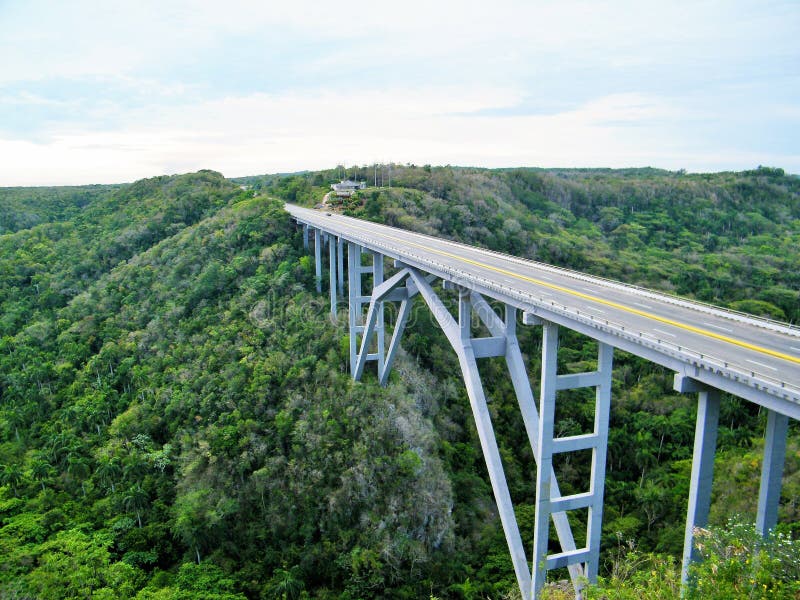
The Bridge of Bacunayagua, inaugurated in September 1959, crosses the canyon, and at 110 meters above the valley floor is the highest bridge in Cuba.[2] Cubans consider it one of the seven wonders of Cuban civil engineering. It was built under the leadership of Civil Engineer Manuel (Manolo) Arvesu.[3] A restaurant with an observation deck is built on the Havana side, while the coastal cove on the Matanzas side includes a campground. The bridge used to divide the provinces of La Habana and Matanzas, but after the reorganization of 2010, it now divides Matanzas Province from the new Mayabeque Province (the island's smallest, except for the city of Havana itself and the Isla de la Juventud).
圖片編號:
102041750
拍攝者:
Pagmarques
點數下載
| 授權類型 | 尺寸 | 像素 | 格式 | 點數 | |
|---|---|---|---|---|---|
| 標準授權 | XS | 480 x 360 | JPG | 13 | |
| 標準授權 | S | 800 x 600 | JPG | 15 | |
| 標準授權 | M | 2000 x 1500 | JPG | 18 | |
| 標準授權 | L | 2581 x 1936 | JPG | 20 | |
| 標準授權 | XL | 3648 x 2736 | JPG | 22 | |
| 標準授權 | MAX | 4000 x 3000 | JPG | 23 | |
| 標準授權 | TIFF | 5159 x 3869 | TIF | 39 | |
| 進階授權 | WEL | 4000 x 3000 | JPG | 88 | |
| 進階授權 | PEL | 4000 x 3000 | JPG | 88 | |
| 進階授權 | UEL | 4000 x 3000 | JPG | 88 |
XS
S
M
L
XL
MAX
TIFF
WEL
PEL
UEL
| 標準授權 | 480 x 360 px | JPG | 13 點 |
| 標準授權 | 800 x 600 px | JPG | 15 點 |
| 標準授權 | 2000 x 1500 px | JPG | 18 點 |
| 標準授權 | 2581 x 1936 px | JPG | 20 點 |
| 標準授權 | 3648 x 2736 px | JPG | 22 點 |
| 標準授權 | 4000 x 3000 px | JPG | 23 點 |
| 標準授權 | 5159 x 3869 px | TIF | 39 點 |
| 進階授權 | 4000 x 3000 px | JPG | 88 點 |
| 進階授權 | 4000 x 3000 px | JPG | 88 點 |
| 進階授權 | 4000 x 3000 px | JPG | 88 點 |


 +886-2-8978-1616
 +886-2-2078-5115


