


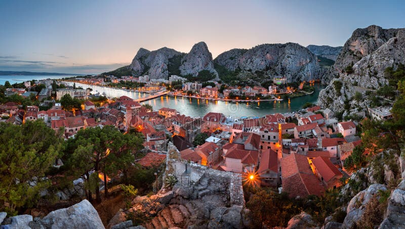
Cetina is a river in southern Croatia. Cetina has its source in the northwestern slopes of Dinara. Rising from a spring at Milasevo near a small village called Cetina it flows 101 kilometres to the Adriatic Sea, in the city of Omis. Bounded to the east by the Dinaric Alps, which rise to an elevation of 2,000 metres, and to the northwest by mountain Svilaja, the majority of the catchment drains calcareous rocks of Cretaceous age, predominantly limestone. Rocks of Triassic and Jurassic age also crop out in the catchment and include dolomitic limestone and flysch. The underlying karst geology controls relief with a series of structurally aligned basins separated by high ridges. The canyon of the river Cetina is very popular among tourists looking for adventure activities like rafting, canyoning, zip-line, rock climbing, kayaking and other outdoor activities. Croatia, Europe.
圖片編號:
197603900
拍攝者:
Rechitansorin
點數下載
| 授權類型 | 尺寸 | 像素 | 格式 | 點數 | |
|---|---|---|---|---|---|
| 標準授權 | XS | 480 x 320 | JPG | 13 | |
| 標準授權 | S | 800 x 534 | JPG | 15 | |
| 標準授權 | M | 2600 x 1735 | JPG | 18 | |
| 標準授權 | L | 2737 x 1826 | JPG | 20 | |
| 標準授權 | XL | 3462 x 2310 | JPG | 22 | |
| 標準授權 | MAX | 4240 x 2829 | JPG | 23 | |
| 標準授權 | TIFF | 3677 x 2454 | TIF | 39 | |
| 進階授權 | WEL | 4240 x 2829 | JPG | 88 | |
| 進階授權 | PEL | 4240 x 2829 | JPG | 88 | |
| 進階授權 | UEL | 4240 x 2829 | JPG | 88 |
XS
S
M
L
XL
MAX
TIFF
WEL
PEL
UEL
| 標準授權 | 480 x 320 px | JPG | 13 點 |
| 標準授權 | 800 x 534 px | JPG | 15 點 |
| 標準授權 | 2600 x 1735 px | JPG | 18 點 |
| 標準授權 | 2737 x 1826 px | JPG | 20 點 |
| 標準授權 | 3462 x 2310 px | JPG | 22 點 |
| 標準授權 | 4240 x 2829 px | JPG | 23 點 |
| 標準授權 | 3677 x 2454 px | TIF | 39 點 |
| 進階授權 | 4240 x 2829 px | JPG | 88 點 |
| 進階授權 | 4240 x 2829 px | JPG | 88 點 |
| 進階授權 | 4240 x 2829 px | JPG | 88 點 |


 +886-2-8978-1616
 +886-2-2078-5115


