


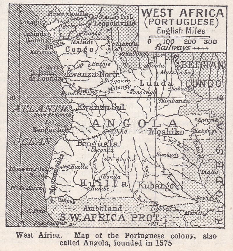
West Africa - Map of the Portuguese colony, also called Angola, founded in 1575. The modern nation state of Angola came into existence after the Portuguese Empire colonised the various local people and created the colony of Angola. The colonial conquest of Angola by the Portuguese was a process which unfolded in various stages over almost 400 years. It began with the establishment of the colony of Luanda in 1575 and ended when, in September 1915, the last king of the Kwanayamo, King Mandume, was defeated by the Portuguese, thus establishing Angola`s contemporary borders.
圖片編號:
235368919
拍攝者:
Mjb6661
點數下載
| 授權類型 | 尺寸 | 像素 | 格式 | 點數 | |
|---|---|---|---|---|---|
| 標準授權 | XS | 445 x 480 | JPG | 13 | |
| 標準授權 | S | 742 x 800 | JPG | 15 | |
| 標準授權 | M | 1601 x 1726 | JPG | 18 | |
| 標準授權 | L | 2153 x 2321 | JPG | 20 | |
| 標準授權 | XL | 2724 x 2936 | JPG | 22 | |
| 標準授權 | MAX | 3336 x 3596 | JPG | 23 | |
| 標準授權 | TIFF | 2264 x 2441 | TIF | 39 | |
| 進階授權 | UEL | 3336 x 3596 | JPG | 88 |
XS
S
M
L
XL
MAX
TIFF
UEL
| 標準授權 | 445 x 480 px | JPG | 13 點 |
| 標準授權 | 742 x 800 px | JPG | 15 點 |
| 標準授權 | 1601 x 1726 px | JPG | 18 點 |
| 標準授權 | 2153 x 2321 px | JPG | 20 點 |
| 標準授權 | 2724 x 2936 px | JPG | 22 點 |
| 標準授權 | 3336 x 3596 px | JPG | 23 點 |
| 標準授權 | 2264 x 2441 px | TIF | 39 點 |
| 進階授權 | 3336 x 3596 px | JPG | 88 點 |


 +886-2-8978-1616
 +886-2-2078-5115


