


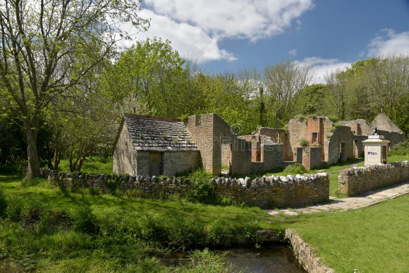
Set at the foot of the south-facing slope of Slievemore mountain, this 'village' consists of the remains of almost 100 traditional stone cottages.They are set either side of an ancient pathway, almost all aligned in the same north-south direction, and they occupy one of the most sheltered areas of Achill Island. The 'village' - literally it is three distinct groups of cottages - extends for a distance of about one mile.settlement dates at least to the Anglo-Norman period (12th Century AD). The presence of a megalithic tomb close to the village, dating from the 3rd or 4th Century BC, indicates habitation in the area some 5000 years ago.The most recent period of habitation came to an end in the early 20th century, when the cottages were used for 'booleying' by the local population. As 'booley' houses they were occupied during the summer months, when cattle would be grazed on the mountainside, but the residents would return to their homes in the villages of Pollagh and Dooagh for the winter months. Achill is thought to be one of the last places in Europe to have practised this type of settlement.
圖片編號:
239979151
拍攝者:
Bo6539
點數下載
| 授權類型 | 尺寸 | 像素 | 格式 | 點數 | |
|---|---|---|---|---|---|
| 標準授權 | XS | 480 x 320 | JPG | 13 | |
| 標準授權 | S | 800 x 534 | JPG | 15 | |
| 標準授權 | M | 2120 x 1414 | JPG | 18 | |
| 標準授權 | L | 2737 x 1826 | JPG | 20 | |
| 標準授權 | XL | 3463 x 2309 | JPG | 22 | |
| 標準授權 | MAX | 7952 x 5304 | JPG | 23 | |
| 標準授權 | TIFF | 11246 x 7501 | TIF | 39 | |
| 進階授權 | WEL | 7952 x 5304 | JPG | 88 | |
| 進階授權 | PEL | 7952 x 5304 | JPG | 88 | |
| 進階授權 | UEL | 7952 x 5304 | JPG | 88 |
XS
S
M
L
XL
MAX
TIFF
WEL
PEL
UEL
| 標準授權 | 480 x 320 px | JPG | 13 點 |
| 標準授權 | 800 x 534 px | JPG | 15 點 |
| 標準授權 | 2120 x 1414 px | JPG | 18 點 |
| 標準授權 | 2737 x 1826 px | JPG | 20 點 |
| 標準授權 | 3463 x 2309 px | JPG | 22 點 |
| 標準授權 | 7952 x 5304 px | JPG | 23 點 |
| 標準授權 | 11246 x 7501 px | TIF | 39 點 |
| 進階授權 | 7952 x 5304 px | JPG | 88 點 |
| 進階授權 | 7952 x 5304 px | JPG | 88 點 |
| 進階授權 | 7952 x 5304 px | JPG | 88 點 |


 +886-2-8978-1616
 +886-2-2078-5115


