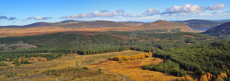
The Wicklow Mountains forms the largest continuous upland area in Ireland. They occupy the whole centre of County Wicklow and stretch outside its borders into Counties Carlow, Wexford and Dublin. Where the mountains extend into County Dublin, they are known locally as the Dublin Mountains.The highest peak is Lugnaquilla at 925 metres. Several major river systems have their source in the mountains, such as the Liffey, Dargle, Slaney and Avoca rivers. Powerscourt Waterfall is the tallest in Ireland at 121 metres. A number of these rivers have been harnessed to create reservoirs for drinking water for Dublin and its surroundings. The Wicklow Mountains experience a temperate oceanic climate with mild, damp summers and cool, wet winters. The dominant habitat of the uplands consists of blanket bog, heath and upland grassland. The uplands support a number of threatened bird species, including merlin and peregrine falcon. The valleys are a mixture of coniferous and deciduous woodland.
圖片編號:
89567883
拍攝者:
Gazzag
點數下載
| 授權類型 | 尺寸 | 像素 | 格式 | 點數 | |
|---|---|---|---|---|---|
| 標準授權 | XS | 480 x 161 | JPG | 13 | |
| 標準授權 | S | 800 x 268 | JPG | 15 | |
| 標準授權 | M | 2994 x 1001 | JPG | 18 | |
| 標準授權 | L | 3865 x 1293 | JPG | 20 | |
| 標準授權 | XL | 4889 x 1636 | JPG | 22 | |
| 標準授權 | MAX | 6550 x 2192 | JPG | 23 | |
| 標準授權 | TIFF | 9263 x 3100 | TIF | 39 | |
| 進階授權 | WEL | 6550 x 2192 | JPG | 88 | |
| 進階授權 | PEL | 6550 x 2192 | JPG | 88 | |
| 進階授權 | UEL | 6550 x 2192 | JPG | 88 |
XS
S
M
L
XL
MAX
TIFF
WEL
PEL
UEL
| 標準授權 | 480 x 161 px | JPG | 13 點 |
| 標準授權 | 800 x 268 px | JPG | 15 點 |
| 標準授權 | 2994 x 1001 px | JPG | 18 點 |
| 標準授權 | 3865 x 1293 px | JPG | 20 點 |
| 標準授權 | 4889 x 1636 px | JPG | 22 點 |
| 標準授權 | 6550 x 2192 px | JPG | 23 點 |
| 標準授權 | 9263 x 3100 px | TIF | 39 點 |
| 進階授權 | 6550 x 2192 px | JPG | 88 點 |
| 進階授權 | 6550 x 2192 px | JPG | 88 點 |
| 進階授權 | 6550 x 2192 px | JPG | 88 點 |


 +886-2-8978-1616
 +886-2-2078-5115


